Home > Urban
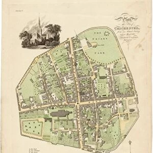
Map Of Chichester, 1812

![]()
Wall Art and Photo Gifts from West Sussex County Council
Map Of Chichester, 1812
Map includes area outside of the city walls. Plan of the liberties of the City of Chichester from an actual survey taken April 1812 by George Loader, Surveyor
Printed Maps Collection
West Sussex Record Office Ref No: PM 10
Media ID 5978151
FEATURES IN THESE COLLECTIONS
> Urban
> West Sussex Record Office
> Printed Maps
MADE IN THE UK
Safe Shipping with 30 Day Money Back Guarantee
FREE PERSONALISATION*
We are proud to offer a range of customisation features including Personalised Captions, Color Filters and Picture Zoom Tools
SECURE PAYMENTS
We happily accept a wide range of payment options so you can pay for the things you need in the way that is most convenient for you
* Options may vary by product and licensing agreement. Zoomed Pictures can be adjusted in the Basket.


![Royal Engineers bomb disposal team at work, [Mar 1941]](/sq/479/royal-engineers-bomb-disposal-team-work-8359434.jpg.webp)
![Chichester St. Peter the Great [Subdeanery] tithe map, 1846-1847](/sq/479/chichester-st-peter-great-subdeanery-tithe-10701869.jpg.webp)